pycsw project status report
Angelos Tzotsos / @tzotsos
Tom Kralidis / @tomkralidis
Jeff McKenna / @mapserving
Outline
- Introduction to pycsw
- Features
- Architecture
- Installation/Configuration
- Client Applications
- Open Data and pycsw Deployments
- Future Developments
- Community
Introduction
- pycsw is a OGC CSW server implementation written in Python.
- Open Source project released under the MIT license.
- Runs on all major platforms (Windows, Linux, Mac OS X)
- OSGeo Project since 11 March 2015
Introduction
- pycsw fully implements the OpenGIS Catalogue Service Implementation Specification [Catalogue Service for the Web]
- pycsw allows for the publishing and discovery of geospatial metadata
Introduction
The project is certified OGC Compliant, and is an OGC Reference Implementation
![]()
pycsw is an official OSGeo Project
![]()
Project History
- 2010: Development started by Tom Kralidis
- Feb 2011: Project officially announced
- Apr 2011: First official release (0.1) was released and already passed all CITE tests
- Jul 2011: Version 1.0 released
- Feb 2012: pycsw included in OSGeoLive 5.5
- Jan 2013: pycsw 1.4 certified as OGC Compliant
- Apr 2013: pycsw entered OSGeo Incubation
- Feb 2014: pycsw powers data.gov
- Mar 2015: pycsw graduates OSGeo Incubation
- Jul 2015: Latest stable release (1.10.2)
Goals
- Lightweight and easy to setup: a standalone catalogue, no GUI or metadata editing front end, designed for the use case of exposing ready-to-go metadata (files or in existing DB) through a CSW interface
- Extensible: the ability to add metadata formats and mapping them to a common information model and core/additional queryables
- OGC compliant: always pass CITE tests
Features
- Harvesting support for WMS, WFS, WCS, WPS, WAF, CSW, SOS
- Implements ISO Metadata Application Profile 1.0.0
- Implements FGDC CSDGM Application Profile for CSW 2.0
- Implements INSPIRE Discovery Services 3.0
- Supports ISO, Dublin Core, DIF, FGDC and Atom metadata models
- Standalone of embedded deployment (CGI or WSGI)
- Transactional capabilities (CSW-T)
- Flexible repository configuration (SQLite, PostgreSQL, PostGIS, MySQL)
- Federated catalogue distributed searching
More features...
- Simple configuration
- Extensible plugin architecture (profiles, repositories/backends)
- Seamless integration with Python environments (e.g. GeoNode, Open Data Catalog)
- Integration with CKAN through ckanext-spatial and ckanext-publicamundi
- Includes commandline utility to administer the metadata repository
- Implements the Search/Retrieval via URL (SRU) search protocol
- Implements OpenSearch
- Realtime XML Schema validation
Standards Support
- OGC CSW 2.0.2
- OGC Filter 1.1.0
- OGC OWS Common 1.0.0
- OGC GML 3.1.1
- OGC SFSQL 1.2.1
- Dublin Core 1.1
- SOAP 1.2
- ISO 19115 2003
- ISO 19139 2007
- ISO 19119 2005
- NASA DIF 9.7
- FGDC CSDGM 1998
- SRU 1.1
- A9 OpenSearch 1.1
- OGC OpenSearch Geo/Time extensions 1.0
Supported CSW Operations
- GetCapabilities
- DescribeRecord
- GetRecords
- GetRecordById
- GetRepositoryItem
- GetDomain
- Harvest
- Transaction
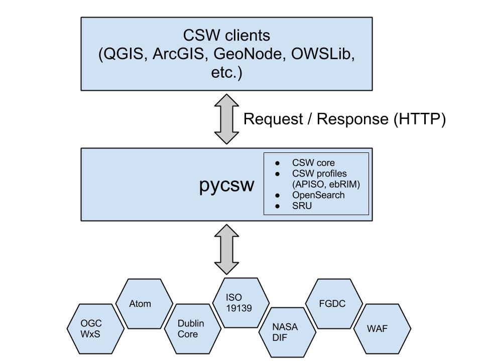
Component Architecture
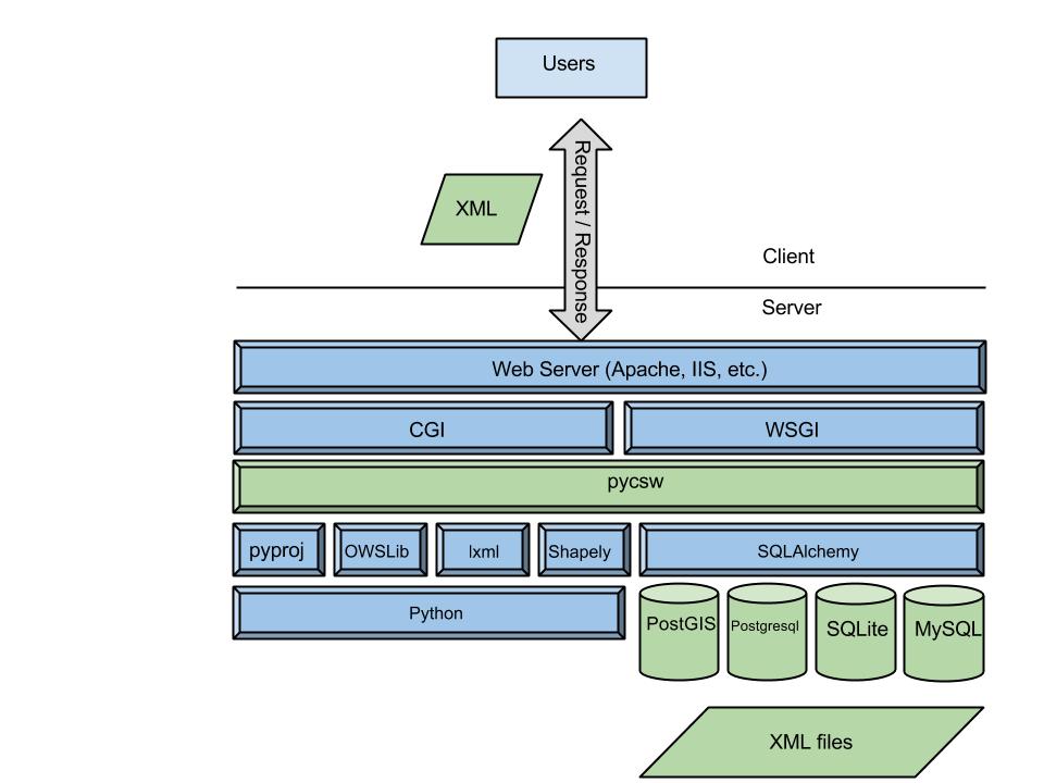
Software Architecture
Installation: the proper way
- Python Package Index (PyPi)
- openSUSE Application:Geo RPM packages
- UbuntuGIS deb packages
- DebianGIS deb packages
4 Minute Install
$ virtualenv pycsw && cd pycsw && . bin/activate
$ git clone git@github.com:geopython/pycsw.git && cd pycsw
$ pip install -e . && pip install -r requirements.txt
$ cp default-sample.cfg default.cfg
$ vi default.cfg
# adjust paths in
# - server.home
# - repository.database
# set server.url to http://localhost:8000/
$ python csw.wsgi
$ curl http://localhost:8000/?service=CSW&version=2.0.2&request=GetCapabilities
OSGeoLive
pycsw is available to test in OSGeoLive since version 5.5
Project Overview and Quickstart Tutorial are included
pycsw 1.10 features
- Repository filtering
- Database connection pooling for WSGI
- PostgreSQL FTS (Full Text Search)
- Link type detection
- OGC OpenSearch Geo/Time extensions 1.0
Upcoming pycsw 2.0 release
- CSW 3.0.0 support has just landed on git master!
- pycsw is planned to be OGC CSW 3 Reference Implementation
- DCAT and GeoDCAT support to be implemented soon
- pycsw 2.0 release is expected after OGC finalizes CSW 3.0 standard
OSGeo Incubation process
- Incubation Application - 9 Dec 2012
- Motion to enter Incubation - Passed on 31 March 2013
- Project Status Document - Finalized on 7 Mar 2014
- Project Graduation Checklist - Finalized on 12 Feb 2015
- Project Provenance Review - Finalized on 12 Feb 2015
- Graduation Recommendation from Mentor - 14 Feb 2015
- Voting from Incubation Committee - 18 Feb 2015
- OSGeo Board approval - 5 Mar 2015
Recent Deployments
- NOAA (data.noaa.gov)
- DOI (data.doi.gov)
- PacIOOS (pacioos.org)
See more at the pycsw Live Deployments Map
Workshop
Oregon Coastal & Marine Data Network pycsw Workshop materials available at http://www.coastalmarinedata.net/?p=229
Workshop source code available on https://github.com/geopython/pycsw-workshop
Getting Involved
Community
http://pycsw.org/community.html
Mailing List and IRC
http://lists.osgeo.org/mailman/listinfo/pycsw-devel
#pycsw and #geopython on Freenode
Source Code, Wiki, Issues on GitHub
https://github.com/geopython/pycsw
Professional support
http://www.osgeo.org/search_profile