pycsw project status 2022

Outline
- Introduction to pycsw
- Features
- Architecture
- Installation
- Latest developments
- Downstream Projects and Deployments
- Roadmap
- Community
Introduction
Introduction
- pycsw is an OGC API - Records and OGC CSW server implementation written in Python
- Open Source project released under the MIT license
- Runs on all major platforms (Windows, Linux, Mac OS X)
- OSGeo Project since 11 March 2015
Introduction
- pycsw fully implements the OpenGIS Catalogue Service Implementation Specification [Catalogue Service for the Web]
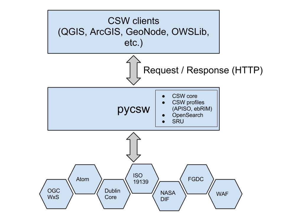
- pycsw also implements OGC API - Records, CQL, OpenSearch, OAI-PMH, SRU, STAC
- pycsw allows for the publishing and discovery of geospatial metadata
Introduction
The project is certified OGC Compliant, and is an OGC Reference Implementation for both CSW 2.0.2 and 3.0.0
Aiming OGC API - Records Reference Implementation
pycsw is an official OSGeo Project
Project History
- 2010: Development started by Tom Kralidis
- Feb 2011: Project officially announced
- Apr 2011: First official release (0.1) released, passing all CITE tests
- Jul 2011: Version 1.0 released
- Feb 2012: pycsw included in OSGeoLive
- Jan 2013: 1.4 certified OGC Compliant, Reference Implementation of OGC CSW 2.0.2
- Apr 2013: pycsw entered OSGeo Incubation
- Feb 2014: pycsw powers data.gov
- Mar 2015: pycsw graduates OSGeo Incubation
Project History
- Jul 2016: Version 2.0 released
- Jul 2016: Reference implementation of OGC CSW 3.0.0
- May 2019: 2.4.0 released
- Dec 2020: Happy 10th birthday!
- Dec 2020: 2.6.0 released
- Jul 2021: OGC API - Records and STAC implementation
- Oct 2021: CQL implementation using pygeofilter
- May 2022: XSL transformations, JSON storage
Goals
- Lightweight and easy to setup: a standalone catalogue, no GUI or metadata editing front end, designed for the use case of exposing ready-to-go metadata (files or in existing DB) through a CSW interface
- Extensible: the ability to add metadata formats and mapping them to a common information model and core/additional queryables
- OGC compliant: always pass CITE tests (integrated into CI)
Features
Features
- Certified OGC Compliant and OGC Reference Implementation for both CSW 2.0.2 and CSW 3.0.0
- Harvesting support for WMS, WFS, WCS, WPS, WAF, CSW, SOS
- Implements ISO Metadata Application Profile 1.0.0
- Implements FGDC CSDGM Application Profile for CSW 2.0
- Implements OGC OpenSearch Geo, Time and EO Extensions
- Implements OGC API - Records (in development)
- Implements STAC API (1.0.0-beta2)
- Implements INSPIRE Discovery Services 3.0
- Supports ISO, Dublin Core, DIF, FGDC, Atom and GM03 metadata models
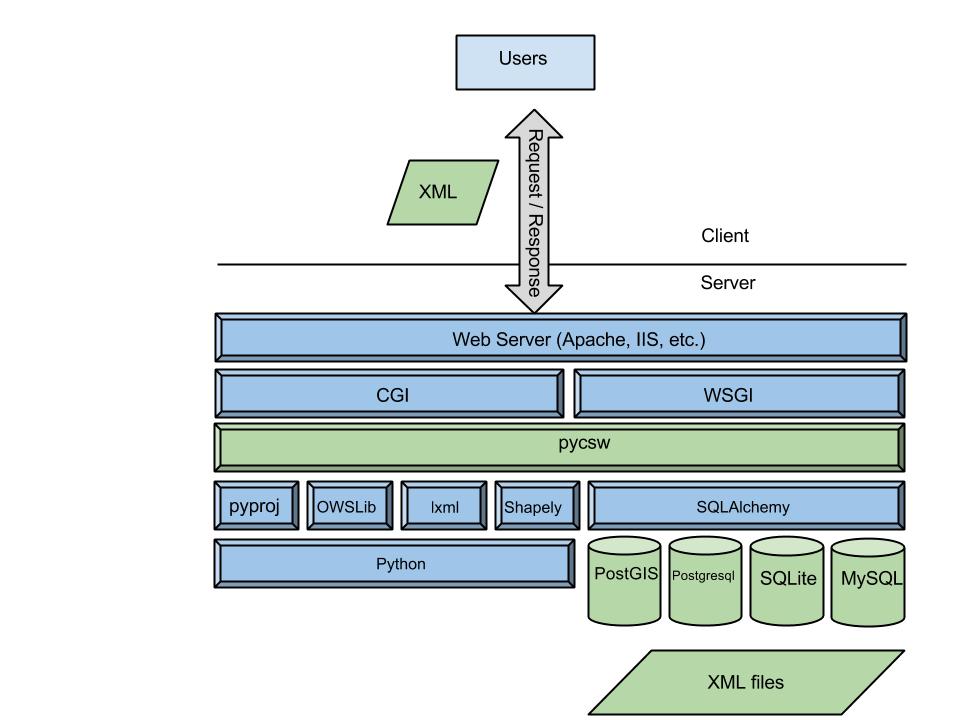
- Standalone of embedded deployment (CGI or WSGI)
- Transactional capabilities (CSW-T)
- Flexible repository configuration (SQLite, PostgreSQL, PostGIS, MySQL)
- Federated catalogue distributed searching
More features...
- Simple configuration
- Extensible plugin architecture (profiles, repositories/backends)
- Seamless integration with Python environments (e.g. GeoNode, HHypermap, Open Data Catalog)
- Integration with CKAN through ckanext-spatial and ckanext-publicamundi
- Includes commandline utility to administer the metadata repository
- Implements the Search/Retrieval via URL (SRU) search protocol
- Implements Open Archives Initiative Protocol for Metadata Harvesting
- Implements Full Text Search capabilities
- Realtime XML Schema validation
Standards Support
- OGC API - Records: Part 1 - Core
- OGC CSW 2.0.2, 3.0.0
- OGC Filter 1.1.0, 2.0.0
- OGC OWS Common 1.0.0, 2.0.0
- OGC SFSQL 1.2.1
- SOAP 1.2
- SRU 1.1
- OAI-PMH 2.0
- OGC OpenSearch 1.0
- STAC API 1.0.0-beta2
- OGC Common Query Language (CQL)
Standards Support
- OGC GML 3.1.1
- Dublin Core 1.1
- ISO 19115 2003, ISO 19115-2 2019
- ISO 19139 2007, ISO 19119 2005
- NASA DIF 9.7
- FGDC CSDGM 1998
- OGC API - Records core record model/schema
- STAC Item
Architecture
Component Architecture

Software Architecture

Installation
Installation: the proper way
- Python Package Index (PyPI)
- Debian (non-free due to the OGC schema licensing: link1 link2)
- Ubuntu
- openSUSE Application:Geo
- MS4W
- Source code available on GitHub
Installation: 4 Minute Install
# Setup a virtual environment:
virtualenv pycsw && cd pycsw && . bin/activate

# Grab the pycsw source code:
git clone https://github.com/geopython/pycsw.git && cd pycsw
pip install -e . && pip install -r requirements-standalone.txt

# Create and adjust a configuration file:
cp default-sample.cfg default.cfg
vi default.cfg
# adjust paths in
# - server.home
# - repository.database
# set server.url to http://localhost:8000/

# Setup the database:
pycsw-admin.py -c setup_db -f default.cfg

# Load records by indicating a directory of XML files, use -r for recursive:
pycsw-admin.py -c load_records -f default.cfg -p /path/to/xml/

# Run the server:
python ./pycsw/wsgi.py

# See that it works!
curl http://localhost:8000/?service=CSW&version=2.0.2&request=GetCapabilities
OSGeoLive
- pycsw is available to test in OSGeoLive since version 5.5
- Project Overview and Quickstart Tutorial are included
Docker - K8s
Latest developments
pycsw 2022 code sprint
- https://pycsw.org/2022/05/29/pycsw-may-2022-codesprint-report.html
- virtual
- 23 - 25 May
- SOLR repository backends
- JSON storage
- XSLT transformations
- bug fixes
- Security, access control and transactions
Initial JSON storage support
- Adds generic metadata object storage (beyond XML)
- Media type qualification:
metadata_type - Initial OGC API - Records core record parser
- Implementation
XSLT transformations
- pycsw's transformation is model driven based on core queryables
- XSLT enables deep transformations (can transform beyond core queryables
- Custom business logic
- Configuration:
# custom XSLT (section format: xslt:input_xml_schema,output_xml_schema)
[xslt:http://www.opengis.net/cat/csw/2.0.2,http://www.isotc211.org/2005/gmd]
xslt=/path/to/my-custom-iso.xslt
OGC Common Query Language (CQL) support
- Representations: CQL TEXT and CQL JSON
- via GET (TEXT or JSON) or POST (JSON)
- Using pygeofilter
- CQL TEXT:
title = 'Lorem ipsum'
title LIKE 'foo%'
{
    "op": "=",
    "args": [
        {
            "property": "title"
        },
        "Lorem ipsum"
    ]
}
Recent Projects and Deployments
EOEPCA
- ESA's Earth Observation Exploitation Platform Common Architecture
- Exploitation Platform: A collaborative, virtual work environment providing access to EO data, algorithms, tools and ICT resources
- Goal to define and agree a re-usable exploitation platform architecture using open interfaces
- pycsw is the Resource Catalogue component of the architecture
Norweigan Meteorological Institute
Serving over 900,000 metadata records for the following projects
- NBS: Norwegian National Ground Segment for Satellite Data
- SIOS: Svalbard Integrated Arctic Earth Observing System
- ADC: Arctic Data Center
- NorDataNet: Norwegian Scientific Data Network
- NMDC: Norwegian Marine Data Centre
- WMO GCW: Global Cryosphere Watch
Enabling data search and access to raw data as well as to data services like OpenDAP, WMS
https:// [nbs, sios, adc, nordatanet, nmdc, gcw ] .csw.met.no
Norweigan Meteorological Institute
Ongoing work
- DIF, DCAT, INSPIRE output profiles
- Continuous deployment of CSW services integrated into a Kubernetes environment
- Automatic update of CSW catalogues with new metadata as they are produced
Meteorological Service of Canada and WMO Information System (WIS)
Migration of Data Collection and Production Centre (DCPC) Catalogue
- Implementation of WMO Core Metadata Profile (WCMP)
- Discovery/search of WMO member weather/climate/water data
Roadmap
OGC API - Records / OGC SWG
- Part of OGC API efforts
- REST/JSON/OpenAPI/Swagger
- pycsw is part of the OGC API - Records Standards Working Group (SWG)
- OGC CQL (text/JSON)
STAC
- STAC Item 1.0 support
- STAC API 1.0-beta2 support
- Tested against pystac-client
Coming soon
- Deeper JSON metadata management support (ingest, harvest)
- Deeper EO support / queryables / granularity
- pygeofilter integration
- updated CLI tooling (Python Click)
Future releases
- pycsw 3.0: Long term release (CSW 2/3)
- pycsw 4.0: OGC API - Records
- Relationship to pygeoapi project
Community
Getting Involved
Community
https://pycsw.org/community.html
Mailing List and Gitter
https://lists.osgeo.org/mailman/listinfo/pycsw-devel
Source Code, Wiki, Issues on GitHub
https://github.com/geopython/pycsw


![This product conforms to the OpenGIS Catalogue Service Implementation Specification [Catalogue Service for the Web], Revision 2.0.2. OGC, OGC®, and CERTIFIED OGC COMPLIANT are trademarks or registered trademarks of the Open Geospatial Consortium, Inc. in the United States and other countries.](https://portal.opengeospatial.org/public_ogc/compliance/Certified_OGC_Compliant_Logo_Web.gif)