pycsw project status 2019
Angelos Tzotsos / @tzotsos
Tom Kralidis / @tomkralidis

Outline
- Introduction to pycsw
- Features
- What's new in pycsw 2.4
- Architecture
- Installation
- Downstream Projects and Deployments
- Roadmap
- Community
Introduction
Introduction
- pycsw is a OGC CSW server implementation written in Python
- Open Source project released under the MIT license
- Runs on all major platforms (Windows, Linux, Mac OS X)
- OSGeo Project since 11 March 2015
Introduction
- pycsw fully implements the OpenGIS Catalogue Service Implementation Specification [Catalogue Service for the Web]
- pycsw also implements OpenSearch, OAI-PMH, SRU
- pycsw allows for the publishing and discovery of geospatial metadata
Introduction
The project is certified OGC Compliant, and is an OGC Reference Implementation for both CSW 2.0.2 and 3.0.0
![]()
pycsw is an official OSGeo Project
Project History
- 2010: Development started by Tom Kralidis
- Feb 2011: Project officially announced
- Apr 2011: First official release (0.1) was released and already passed all CITE tests
- Jul 2011: Version 1.0 released
- Feb 2012: pycsw included in OSGeoLive
- Jan 2013: pycsw 1.4 certified as OGC Compliant
- Apr 2013: pycsw entered OSGeo Incubation
- Feb 2014: pycsw powers data.gov
- Mar 2015: pycsw graduates OSGeo Incubation
- Jul 2016: Latest stable release (2.0.0)
- Jul 2016: Reference implementation of OGC CSW 3.0.0
- Mar 2018: 2.2.0 released
- May 2019: 2.4.0 released
Goals
- Lightweight and easy to setup: a standalone catalogue, no GUI or metadata editing front end, designed for the use case of exposing ready-to-go metadata (files or in existing DB) through a CSW interface
- Extensible: the ability to add metadata formats and mapping them to a common information model and core/additional queryables
- OGC compliant: always pass CITE tests
Features
Features
- Certified OGC Compliant and OGC Reference Implementation for both CSW 2.0.2 and CSW 3.0.0
- Harvesting support for WMS, WFS, WCS, WPS, WAF, CSW, SOS
- Implements ISO Metadata Application Profile 1.0.0
- Implements FGDC CSDGM Application Profile for CSW 2.0
- Implements OGC OpenSearch Geo and Time Extensions
- Implements INSPIRE Discovery Services 3.0
- Supports ISO, Dublin Core, DIF, FGDC, Atom and GM03 metadata models
- Standalone of embedded deployment (CGI or WSGI)
- Transactional capabilities (CSW-T)
- Flexible repository configuration (SQLite, PostgreSQL, PostGIS, MySQL)
- Federated catalogue distributed searching
- Python 2 and 3 compatible
More features...
- Simple configuration
- Extensible plugin architecture (profiles, repositories/backends)
- Seamless integration with Python environments (e.g. GeoNode, HHypermap, Open Data Catalog)
- Integration with CKAN through ckanext-spatial and ckanext-publicamundi
- Includes commandline utility to administer the metadata repository
- Implements the Search/Retrieval via URL (SRU) search protocol
- Implements Open Archives Initiative Protocol for Metadata Harvesting
- Implements Full Text Search capabilities
- Realtime XML Schema validation
Standards Support
- OGC CSW 2.0.2, 3.0.0
- OGC Filter 1.1.0, 2.0.0
- OGC OWS Common 1.0.0, 2.0.0
- OGC GML 3.1.1
- OGC SFSQL 1.2.1
- Dublin Core 1.1
- SOAP 1.2
- ISO 19115 2003
- ISO 19139 2007
- ISO 19119 2005
- NASA DIF 9.7
- FGDC CSDGM 1998
- SRU 1.1
- OAI-PMH 2.0
- OGC OpenSearch 1.0
Supported CSW Operations
- GetCapabilities
- DescribeRecord
- GetRecords
- GetRecordById
- GetRepositoryItem
- GetDomain
- Harvest
- UnHarvest
- Transaction
What's new in pycsw 2.4.0
Harvesting Enhancements
- WMS 1.3.0
- WPS processes
Plugin enhancements
- Abstraction of query filters (previously bound to SQL)
- OGC Filter XML -> Python dict <-> repository query grammar
- Enables search engine backends (Elasticsearch, GraphQL, etc.)
Docker Support
- Official Docker image on Docker Hub
- Documentation
docker run -p 8000:8000 geopython/pycsw
New Branding
Thanks to Amanda Yoshiizumi!
Get your stickers at the OSGeo booth!
More improvements
- Updated testing framework (py.test)
- Translation updates (Chinese)
- Enhanced harvesting workflows
- paging improvements
Meetings
- July 2018: dev meeting
- June 2019: OGC API Hackathon
Architecture
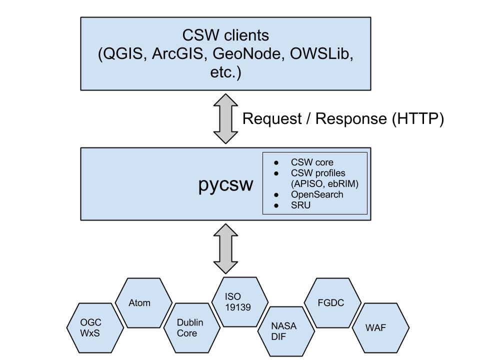
Component Architecture
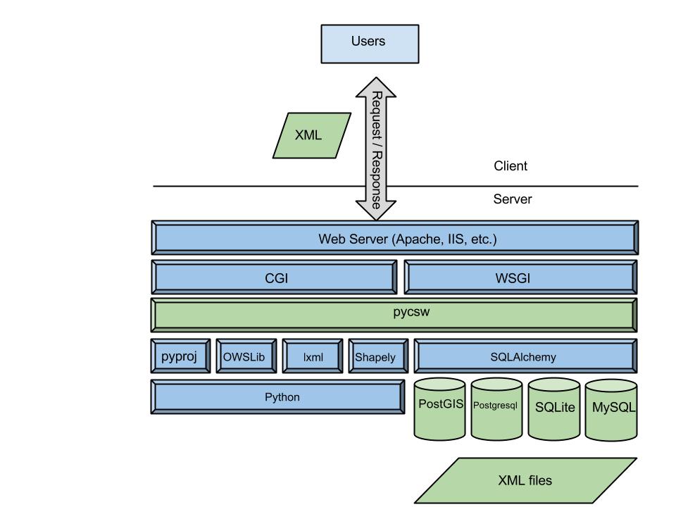
Software Architecture
Installation
Installation: the proper way
- Python Package Index (PyPI)
- Debian (non-free due to the OGC schema licensing: link1 link2)
- Ubuntu
- openSUSE Application:Geo
- Source code available on GitHub
Installation: 4 Minute Install
# Setup a virtual environment:
virtualenv pycsw && cd pycsw && . bin/activate

# Grab the pycsw source code:
git clone https://github.com/geopython/pycsw.git && cd pycsw
pip install -e . && pip install -r requirements-standalone.txt

# Create and adjust a configuration file:
cp default-sample.cfg default.cfg
vi default.cfg
# adjust paths in
# - server.home
# - repository.database
# set server.url to http://localhost:8000/

# Setup the database:
pycsw-admin.py -c setup_db -f default.cfg

# Load records by indicating a directory of XML files, use -r for recursive:
pycsw-admin.py -c load_records -f default.cfg -p /path/to/xml/

# Run the server:
python ./pycsw/wsgi.py

# See that it works!
curl http://localhost:8000/?service=CSW&version=2.0.2&request=GetCapabilities
OSGeo-Live
- pycsw is available to test in OSGeoLive since version 5.5
- Project Overview and Quickstart Tutorial are included
Downstream Projects and Deployments
GeoNode
Open Source Geospatial Content Management System
- GeoNode is a web-based application and platform for developing geospatial information systems (GIS) and for deploying spatial data infrastructures (SDI).
- pycsw is embeded and enabled as the default CSW server
CKAN
- An Open Source Data Management System for powering data hubs and data portals
- Publishing, sharing, finding and using data
- pycsw is embeded in spatial extension (ckanext-spatial)
- Tight integration implemented in PublicaMundi extension
Open Data Catalog
- Code For America Application
- Open data publishing
- pycsw is embeded and enabled out of the box
HHypermap (Harvard Hypermap)
- HHypermap (Harvard Hypermap) Registry is an application that manages OWS, Esri REST, and other types of map service harvesting, and maintains uptime statistics for services and layers
- pycsw 2.0.0 is embedded
Data.gov
- US Government Open Data portal is based on CKAN
- Since 2014 pycsw is deployed as the data.gov CSW implementation serving 2 million datasets
Recent Deployments
- British Antarctic Survey
- Copernicus Atmosphere Monitoring Service
- Earth Observation Data Centre for Water Resources Monitoring
See more at the pycsw Live Deployments Map
Roadmap
OGC API efforts
- Evolution of OGC API standards
- REST/JSON/OpenAPI/Swagger
- See the pygeoapi presentation for more info
- pycsw is part of the OGC CAT4.0 standards working group
Future OGC standards
- OGC API - Common (OWS Common)
- OGC API - Features (WFS)
- OGC API - Coverages (WCS)
- OGC API - Maps and Tiles (WMS/WMTS)
- OGC API - Processing (WPS)
- OGC API - Records (CSW)
Future releases
- pycsw 3.0: Long term release (CSW 2/3)
- pycsw 4.0: OGC API - Records / CAT 4.0
- Relationship to pygeoapi project
Community
Getting Involved
Community
https://pycsw.org/community.html
Mailing List and IRC
https://lists.osgeo.org/mailman/listinfo/pycsw-devel
Gitter channel, Freenode (#pycsw and #geopython)
Source Code, Wiki, Issues on GitHub
https://github.com/geopython/pycsw
Professional support
Workshop
Oregon Coastal & Marine Data Network pycsw Workshop materials available at http://www.coastalmarinedata.net/?p=229
Workshop source code available on https://github.com/geopython/pycsw-workshop